

East Davis CA Homes For Sale
Davis, California
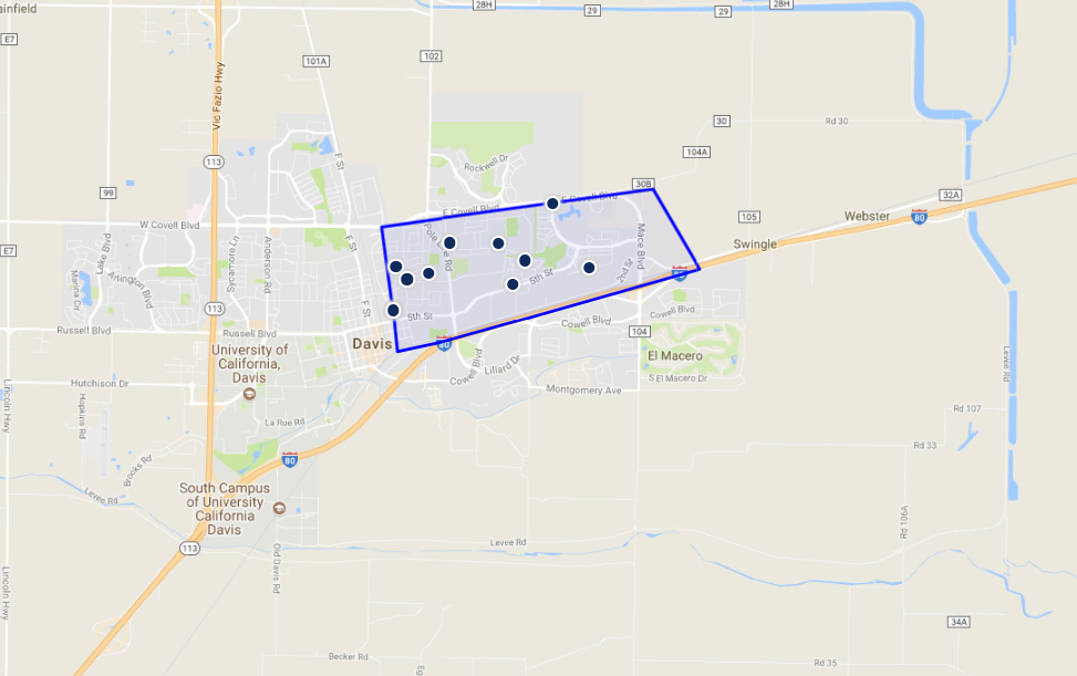
East Davis is located just north of Interstate 80. It is bounded by E. Covell Boulevard on the north, Interstate 80 on the south, J Street on the west and the Davis city limits on the east side.
East Davis CA Real Estate Guide:
ListingsNeighborhoodsNearby CitiesReal Estate AgentsHome Improvement ResourcesSchool Information East Davis In Depth
Neighborhoods Nearby East Davis
Davis has distinct neighborhoods, each with its own character and overall vibe. From the energetic urban downtown area to the University area, there is a neighborhood for everyone here.
East Davis Home Improvement Resources
Perhaps you’re not quite ready to sell your home, but need to make a few crucial updates in order to make your home market ready. Or maybe you need to make improvements before moving into your newly purchased home. Everything from kitchen and bath remodels, additions, or full cosmetic overhaul, no project is too big or too small.
East Davis Real Estate Agents
We have knowledgeable real estate agents ready and waiting to help you buy or sell the perfect home in Davis. Each of our associates is a host of valuable information about the city and all that it has to offer.
East Davis Zip Codes
East Davis Market Stats
- 2016 Average sale price: $ 571,916
- 2016 # of Homes Sold: 134
- 2016 Average Days on Market: 23
East Davis Nearby Cities
Davis is on the western side of Yolo County, located near major city hubs and smaller urban cores, alike.
East Davis School Information
East Davis is home to many schools, from elementary to adult schools, both public and private. No matter where you live in East Davis, a great education is just around the corner.
PUBLIC ELEMENTARY (3 SCHOOLS)
BIRCH LANE ELEMENTARY SCHOOL
Grades: K-6
1600 BIRCH LN
DAVIS, CA 95618
DAVIS SCHOOL FOR INDEPENDENT STUDY
Grades: K- 12
526 B ST
DAVIS, CA 95616
FRED T. KOREMATSU ELEMENTARY SCHOOL AT MACE RANCH
Grades: K-6
3100 LOYOLA DR
DAVIS, CA 95618
PUBLIC MIDDLE (4 SCHOOLS)
DAVIS SCHOOL FOR INDEPENDENT STUDY
Grades: K-12
526 B ST
DAVIS, CA 95616
DA VINCI CHARTER ACADEMY
Grades: 7 - 12
1400 E 8TH ST
DAVIS, CA 95616
FRANCES ELLEN WATKINS HARPER JUNIOR HIGH SCHOOL
Grades: 7-9
4000 E COVELL BLVD
DAVIS, CA 95618
OLIVER WENDELL HOLMES JUNIOR HIGH SCHOOL
Grades: 7-9
1220 DREXEL DR
DAVIS, CA 95616
PUBLIC HIGH (4 SCHOOLS)
DAVIS SCHOOL FOR INDEPENDENT STUDY
Grades: K - 12
1400 E 8TH ST
DAVIS, CA 95616
DA VINCI CHARTER ACADEMY
Grades: 7-12
1504 FALLBROOK ST
DAVIS, CA 95618
DAVIS SENIOR HIGH SCHOOL
Grades: 10-12
315 W 14TH ST
DAVIS, CA 95616
KING (MARTIN LUTHER) HIGH (CONTINUATION) SCHOOL
Grades: 10-12
635 B ST
DAVIS, CA 95618
PRIVATE (5 SCHOOLS)
DAVIS WALDORF SCHOOL
Grades: PRE-8
3100 SYCAMORE LN
DAVIS, CA 95616
GRACE VALLEY CHRISTIAN ACADEMY
Grades: K-9
27173 COUNTY ROAD 98
DAVIS, CA 95616
PEREGRINE SCHOOL - SOUTH (PS)
Grades:
2650 LILLARD DR
DAVIS, CA 95618
REDBUD MONTESSORI SCHOOL
Grades: PRE-K
27082 PATWIN RD
DAVIS, CA 95616
TENDER LEARNING CARE
Grades: PRE-K
1818 LAKE BLVD
DAVIS, CA 95616
CATHOLIC (1 SCHOOL)
ST JAMES SCHOOL
Grades: K-8
1215 B ST
DAVIS, CA 95616
PUBLIC ADULT & OTHER (4 SCHOOLS)
DAVIS SENIOR HIGH SCHOOL
Grades: 10-12
315 W 14TH ST
DAVIS, CA 95616
FRED T. KOREMATSU ELEMENTARY SCHOOL AT MACE RANCH
Grades: K-6
3100 LOYOLA DR
DAVIS, CA 95618
MARGUERITE MONTGOMERY ELEMENTARY SCHOOL
Grades: K - 6
1441 DANBURY ST
DAVIS, CA 95618
DAVIS ADULT EDUCATION
Grades:
315 W 14TH ST
DAVIS, CA 95616
Downtown Davis In Depth
Location
East Davis is located just north of Interstate 80. It is bounded by E. Covell Boulevard on the north, Interstate 80 on the south, J Street on the west and the Davis city limits on the east side.
Parks & Recreation
East Davis has many wonderful parks for residents to enjoy including Central Park, Cedar Park, Davis Community Gardens, Toad Hollow Off Leash Dog Park, Chestnut Park, Slide Hill Park with Manor Pool Complex, Mace Ranch Park and Bike Path, La Playa Park and John Barovetto Park.
Demographics
There are currently approximately 65,317 people living in the city of Davis. The population density 6,606 per square mile. The median age of resident in the city is 26.9, which is Much lower than both the state average of 35.6 and the national average of 37.4. Most households are families of 3. The majority of residents are English speaking, with the next commonly spoken language being Spanish. The workforce is primarily made up of blue collar jobs, with roughly 37% of the force being white collar positions.
Weather
The Davis climate resembles that of nearby Sacramento and is typical of California's Central Valley Mediterranean climate regime: dry, hot summers and cool, rainy, winters. Average temperatures range from 46 °F (8 °C) in December and January to 75 °F (24 °C) in July and August. Thick ground fog called tule fog settles into Davis during late fall and winter. This fog can be dense with visibility to nearly zero. As in other areas of northern California, the tule fog is a leading cause of road accidents in the winter season.
Attractions
Celebrate Davis is the annual free festival held by the Davis Chamber of Commerce. It features booths by Davis businesses, live music, food vendors, live animals, activities like rock climbing and zip-line. It concludes with fireworks after dark. Parking is problematic, so most people ride their bikes and use the free valet parking.
Picnic Day is an annual event at the University of California, Davis and is always held on the third Saturday in April. It is the largest student-run event in the US. Picnic Day starts off with a parade, which features the UC Davis California Aggie Marching Band-uh!, and runs through campus and around downtown Davis and ends with the Battle of the Bands, which lasts until the last band stops playing (sometimes until 2 am). There are over 150 free events and over 50,000 attend every year. Other highlights include: the Dachshund races, a.k.a. the Doxie Derby, held in the Pavilion; the Davis Rock Challenge, the Chemistry Magic Show, and the sheep dog trials.
The Davis Transmedia Art Walk is a free, self-guided, public art tour includes 23 public murals, 16 sculptures, and 15 galleries and museums all in downtown Davis and the University of Davis campus. A free Davis Art Walk map serves as a detailed guide to the entire collection. The art pieces are all within walking distance of each other. The walk is a roughly circuitous path that can be completed within an hour or two. Every piece of art on the Art Walk has been embedded with an RFID chip. Using a cell phone that supports this technology, you access multimedia files that relate to each work. You can even leave a comment or "burn your own message" for other visitors to see. Artist hosted tours are held on the weekend by appointment only. To pick up a copy of the Davis Art Walk map, visit the Yolo County Visitors Bureau (132 E St., Suite 200; (530) 2978-1900) or the John Natsoulas Center for the Arts (521 1st St.; (530) 756-3938).
UC Davis ArboretumThe UC Davis Arboretum is an arboretum and botanical garden. Plants from all over the world grow in different sections of the park. There are notable oak and native plant collections and a small redwood grove. A small waterway spans the arboretum along the bed of the old North Fork of Putah Creek. Occasionally herons, kingfishers, and cormorants can be seen around the waterways, as well as the ever-present ducks. Tours of the arboretum led by volunteer naturalists are often held for grade-school children.
The Davis Farmers Market is held every Wednesday evening and Saturday morning. Participants sell a range of fruits and vegetables, baked goods, dairy and meat products (often from certified organic farms), crafts, and plants and flowers. From April to October, the market hosts Picnic in the Park, with musical events and food sold from restaurant stands.The Davis Farmers Market won first place in the 2009, and second place in the 2010 America's Favorite Farmers Markets held by the American Farmland Trust under the large Farmers market classification.
Davis' Toad Tunnel is a wildlife crossing that was constructed in 1995 and has drawn much attention over the years, including a mention on The Daily Show. Because of the building of an overpass, animal lovers worried about toads being killed by cars commuting from South Davis to North Davis, since the toads hopped from one side of a dirt lot (which the overpass replaced) to the reservoir at the other end. After much controversy, a decision was made to build a toad tunnel, which runs beneath the Pole Line Road overpass which crosses Interstate 80. The project cost $14,000. The tunnel is 21 inches (53 cm) wide and 18 inches (46 cm) high.
The tunnel has created problems of its own. The toads originally refused to use the tunnel and so the tunnel was lit to encourage its use. The toads then died from the heat of the lamps inside the tunnel. Once through the tunnel, the toads also had to contend with birds who grew wise to the toad-producing hole in the ground. The exit to the toad tunnel has been decorated by the Postmaster to resemble a toad town.
Community Resources
Davis Police Department is located in East Davis. Additional community resources are available throughout areas of Davis.
Healthcare Resources
Heathcare resources are available throughout areas of Davis.
Education
There are numerous schools located throughout the city for children to attend. East Davis is served by the Davis Joint Unified School District which has 17 schools There are also parochial schools, pre-schools, and day care centers in the area. Over 30 colleges and universities within Sacramento Valley are within easy commuting distance from East Davis.
Real Estate
There is a wide range of homes available to buy or rent in East Davis. The median sales price is approximately $577,000. A majority of the available homes are single-family homes, built during the mid-late 20th century. East Davis's strategic location, extensive transportation networks, readily available and value-priced properties, and proximity to Northern California's attractions all make it a prime location to live.

")


© 2023 Your Brokerage and Moxi Works © 2023 Coldwell Banker Real Estate LLC. A Realogy Company. All Rights Reserved. Coldwell Banker Real Estate LLC fully supports the principles of the Fair Housing Act and the Equal Opportunity Act. Each Office is Independently Owned and Operated. Coldwell Banker®, the Coldwell Banker Logo and "We Never Stop Moving" are registered service marks owned by Coldwell Banker Real Estate LLC. BRE# 01935235
